GeoAIDA (Geo Automatic Image Data Analyser)

TNT members involved in this project:
Prof. Dr.-Ing. Jörn Ostermann
Dr.-Ing. Martin Pahl
Show all

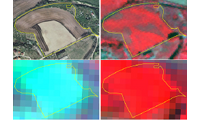
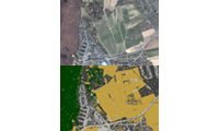
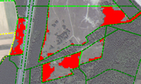
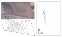
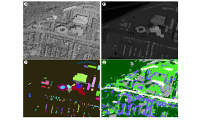
The analysis of complex images e.g. aerial images of periphery and downtown scenes is not possible with an approach only on sub-symbolic basis.

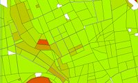
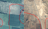
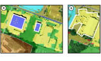
The interpretation of periphery and downtown scenes with the automatic extraction of the road network.

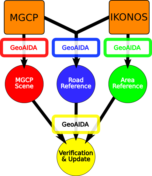
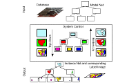
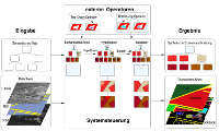
The use of a priori knowledge and the modeling of this knowledge in a semantic network to make the knowledge useable for an automatic image interpretation. GeoAIDA is a system for controlling the interpretation of remote sensing data for the purpose of land use analysis.

Show recent publications only
  • Conference Contributions
    • Petra Helmholz, Torsten Büschenfeld, Uwe Breitkopf, Sönke Müller, Franz Rottensteiner
      Multitemporal Quality Assessment of Grassland and Cropland Objects of a Topographic Dataset
      ISPRS Archives of Photogrammetry, Remote Sensing and Spatial Information Science, accepted for publication, International Society for Photogrammetry and Remote Sensing, Melbourne, Australia, August 2012
    • Christian Becker, Martin Pahl, Joern Ostermann
      Automatic Quality Assessment of GIS Data based on Object Coherence
      Proceedings of the 4th GEOBIA, GeoBIA 2012, pp. 47-52, Rio de Janeiro, Brazil, May 2012
    • Torsten Büschenfeld, Jörn Ostermann
      Edge Preserving Land Cover Classification Refinement using Mean Shift Segmentation
      Proceedings of the 4th GEOBIA, pp. 242-247, Rio de Janeiro, Brasil, May 2012
    • Petra Helmholz, Christian Becker, Uwe Breitkopf, Torsten Büschenfeld, Andreas Busch, Dietmar Grünreich, Christian Heipke, Sönke Müller, Jörn Ostermann, Martin Pahl, Karsten Vogt, Marcel Ziems
      Semiautomatic Quality Control of Topographic Reference Datasets
      ISPRS Commission 4 Symposium, Orlando, Florida, November 2010
    • Karsten Vogt, Björn Scheuermann, Christian Becker, Torsten Büschenfeld, Bodo Rosenhahn, Jörn Ostermann
      Automated Extraction of Plantations from Ikonos Satellite Imagery using a Level Set Based Segmentation Method
      ISPRS Technical Commission VII Symposium, International Society for Photogrammetry and Remote Sensing, Vol. 38, No. 7, pp. 275-280, 2010
    • Christian Becker, Marcell Ziems, Torsten Büschenfeld, Christian Heipke, Sönke Müller, Jörn Ostermann, Martin Pahl
      Multi-Hierarchical Quality Assessment of Geospatial Data
      ISPRS, International Society for Photogrammetry and Remote Sensing, Beijing, 2008
    • Petra Helmholz, Christian Becker, Christian Heipke, Soenke Müller, Joern Ostermann, Martin Pahl, Marcel Ziems
      Semi-automatic verification of geodata for quality management and updating of GIS
      IntArchPhRS, Vol. 36, No. 4, pp. 9-13, Urumchi, August 2007
    • A. Busch, M. Gerke, D. Grünreich, C. Heipke, P. Helmholz, C.-E. Liedtke, S. Müller
      Automated Verification of a Topographic Dataset Using IKONOS Imagery
      IntArchPhRS, pp. 134-139, Goa, 2006
    • Andreas Busch, Markus Gerke, Dietmar Grünreich, Christian Heipke, Claus-Eberhard Liedtke, Soenke Müller
      Automatisierte Verifikation topographischer Geoinformationen unter Nutzung optischer Fernerkundungsdaten: Systemdesign und praktische Ergebnisse
      Photogrammetrie - Fernerkundung - Geoinformation, Vol. 127, No. 2, pp. 111-122, April 2005
    • Martin Weis, Sönke Müller, Claus-Eberhard Liedtke, Martin Pahl
      A framework for GIS and imagery data fusion in support of cartographic updating
      Information Fusion, Vol. 6, No. 4, pp. 311-317, 2005
    • Juergen Bückner, Martin Pahl, Oliver Stahlhut, Claus-Eberhard Liedtke
      geoAIDA - A Knowledge Based Automatic Image Data Analyser for Remote Sensing Data
      CIMA 2001, Bangor, Wales, UK, June 19th-22nd 2001, 2001
    • C.-E. Liedtke, J. Bückner, M. Pahl, O. Stahlhut
      Knowledge based system for the interpretation of complex scenes
      Ascona 2001 / Schweiz, 2001
  • Journals
    • Petra Helmholz, Christian Becker, Uwe Breitkopf, Torsten Büschenfeld, Andreas Busch, Carola Braun, Dietmar Grünreich, Sönke Müller, Jörn Ostermann, Martin Pahl, Franz Rottensteiner, Karsten Vogt, Marcel Ziems, Christian Heipke
      Semi-automatic Quality Control of Topographic Data Sets
      Photogrammetric Engineering & Remote Sensing, Vol. 78, No. 9, pp. 959--972, September 2012
    • Christian Becker, Martin Pahl, Joern Ostermann
      Mono-Temporal GIS Update Assistance System based on unsupervised Coherence Analysis and Evolutionary Optimisation
      ISPRS Annals of the Photogrammetry, Remote Sensing and Spatial Information Sciences, International Society for Photogrammetry and Remote Sensing, pp. 233-238, Melbourne, Australia, August 2012
    • Torsten Büschenfeld, Jörn Ostermann
      Automatic Refinement of Training Data for Classification of Satellite Imagery
      ISPRS Annals of Photogrammetry, Remote Sensing and Spatial Information Science, International Society for Photogrammetry and Remote Sensing, Vol. 1, No. 7, pp. 117-122, Melbourne, Australia, August 2012
  • Books
    • Martin Pahl
      Architektur eines wissensbasierten Systems zur Interpretation multisensorieller Fernerkundungsdaten
      ibidem, July 2003